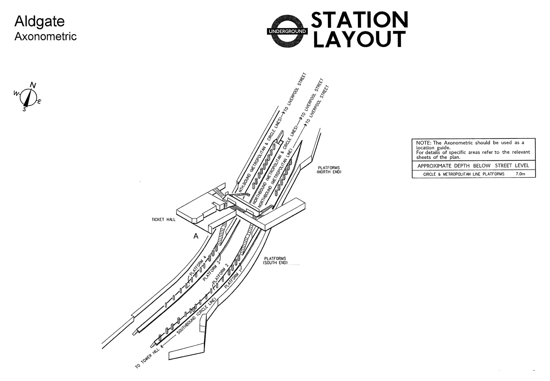
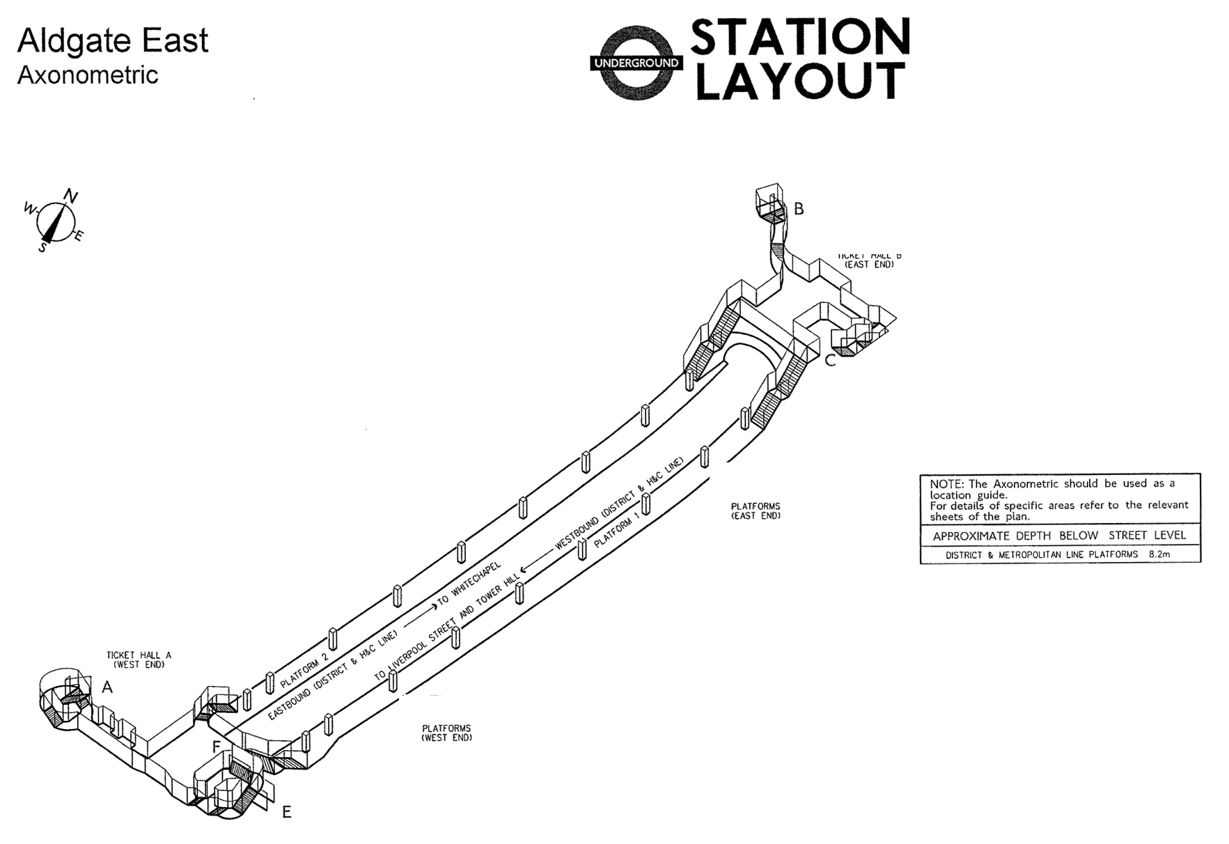
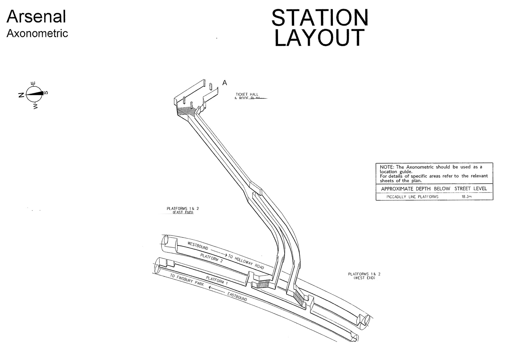
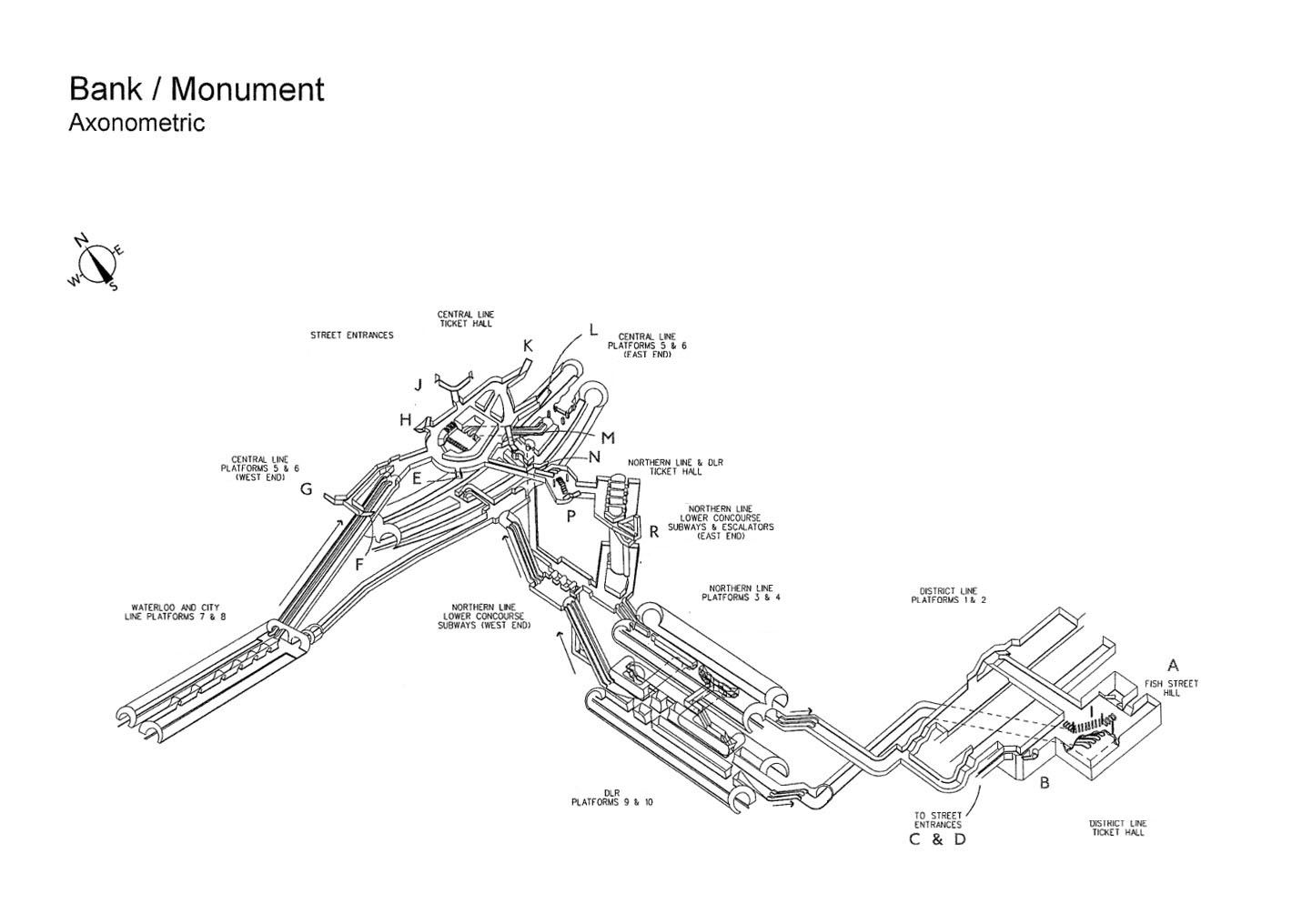
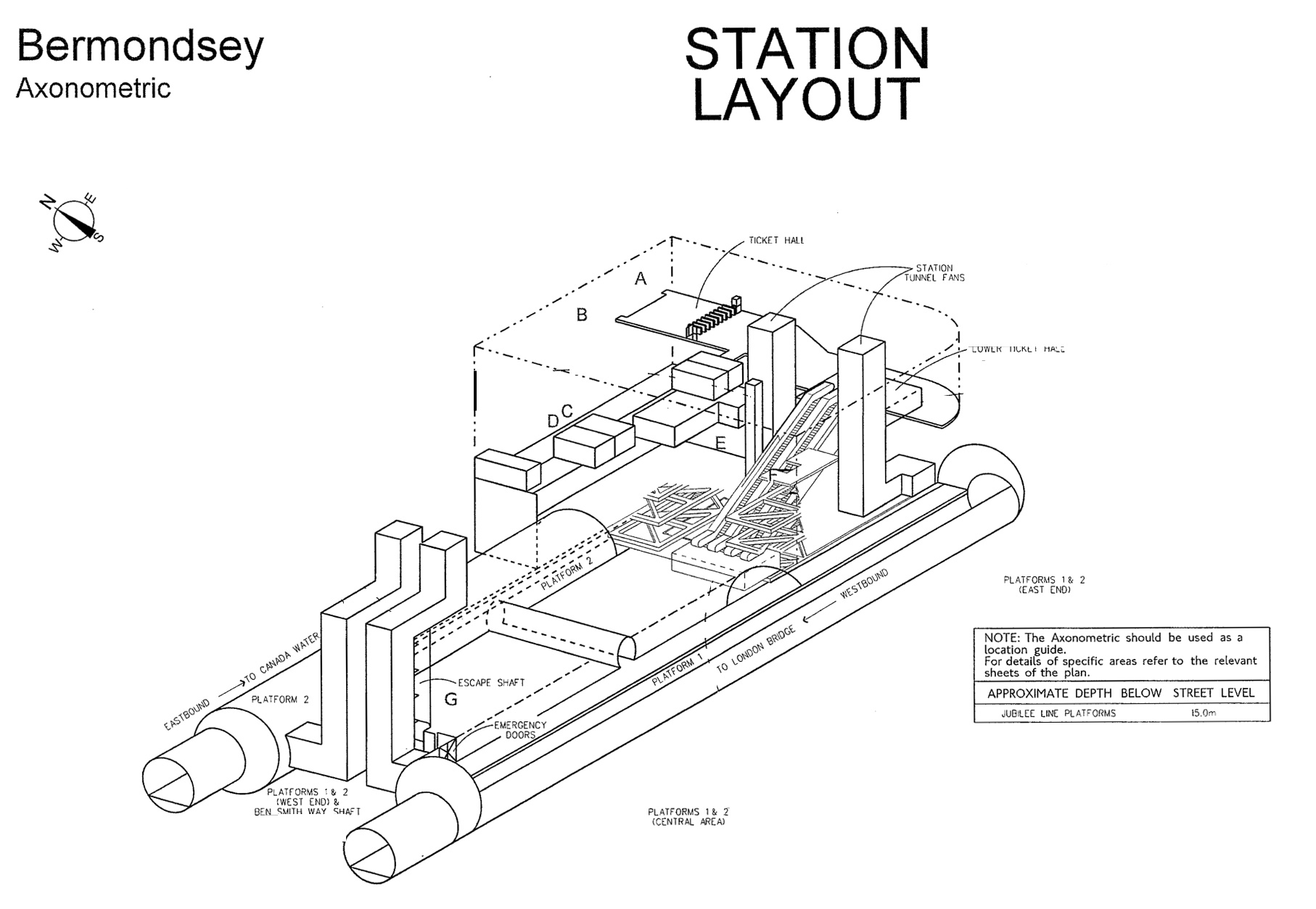
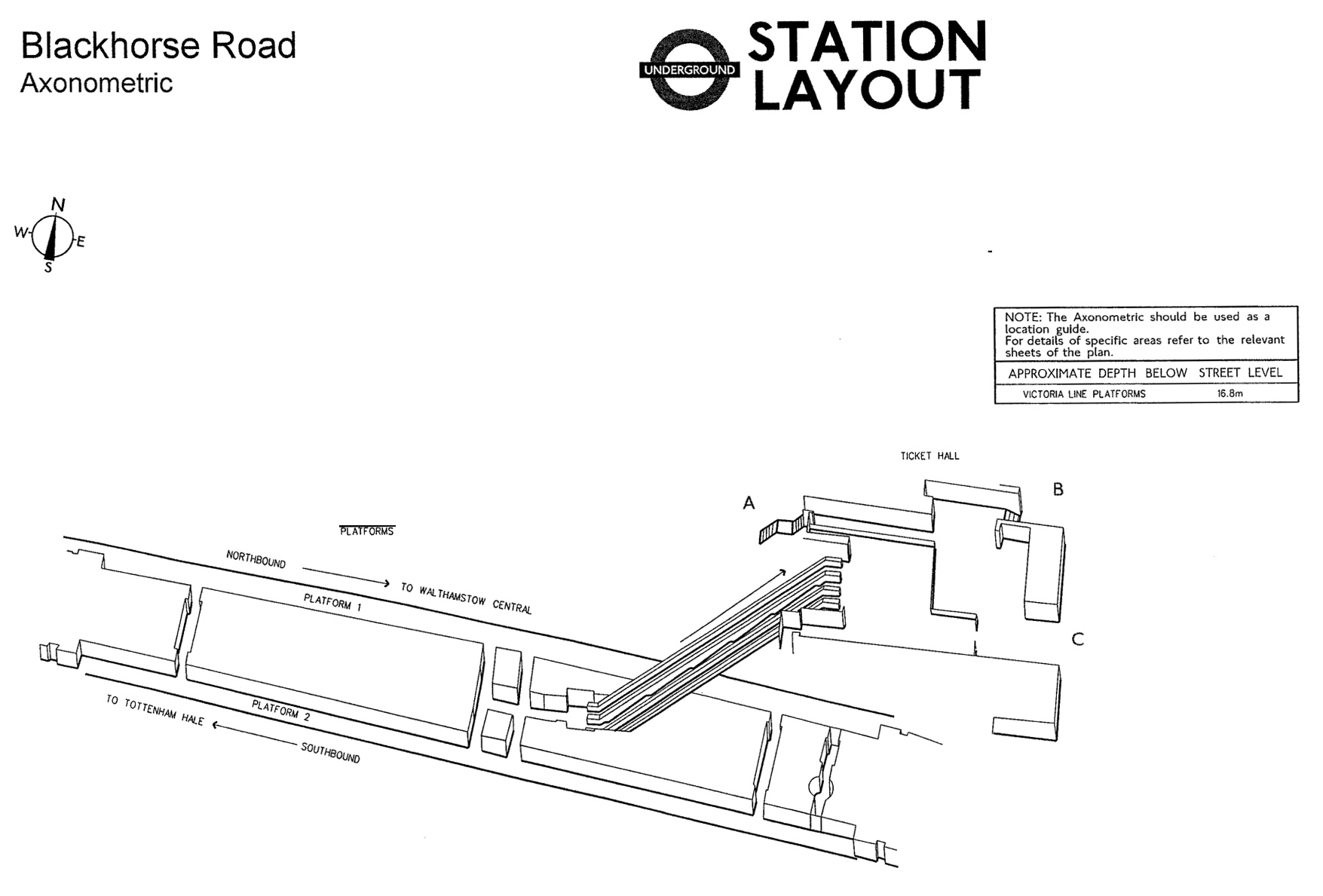
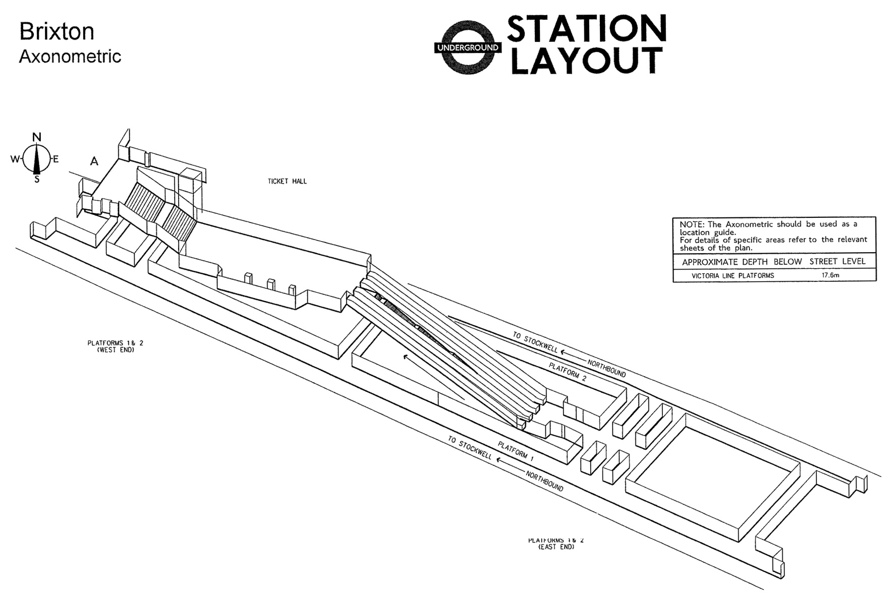
TfL has released a batch of documents that show almost every underground station in glorious 3D format.
They are technically axonometric diagrams, which is 3D-like, but not to scale, which becomes obvious when you see some of the vertiginous descents offered on some stairs and escalators.
In total, some 120 stations with underground tunnels are represented in this motherlode of tube and map geekery. I’ve removed the redacted black blobs that are scatted over the originals, and generally cleaned them up a bit
To make displaying 124 large maps easier, I have broken them down into 5 pages.
Click on the drawings to enlarge them.
Note, the diagrams are indicative of layouts, and are not updated with changes (temporary or permanent).
Stations A-B


Baker Street


Stations A-B
Original reference files here.
Copyright
Copyright of the diagrams is owned by TfL. If you would like to re-use the information please contact TfL. Requests for re-use will be considered in accordance with the Re-use of Public Sector Information Regulations 2005 and, where the disclosed information is a dataset, section 11a of the Freedom of Information Act.


Someone is cheating (?)
I immediately checked “Kings Cross” (as probably the most complicated on the system)
ONLY the southern ticket hall & entrance are shown.
Ther are numerous tunnels & walkways from the northern t-hall down & along to various lines.
NOT shown.
Oops, & naughty!
There are 2 pages. 1 shows the northern ticket hall and associated tunnels. the other one shows the western ticket hall and tube ticket halls. they will not show the kings cross or st pancras station layouts as they are not part of the underground. however both of those have their own layouts on network rail websites.
Interesting but the title is such clickbait. “Every underground station”… you have 120 out of 270… less than half.
It shows all the “underground” stations. The tube stations that are above ground lack the tunnels to be included in maps of tunnels.
That makes sense. At first I thought my former stop (Baron’s Court) didn’t make the cut. Is there a resource for diagrams of the above-ground TFL stations?
Great resource. Baker St seems to be missing despite having 3 lines in tunnels.
Where’s Parson’s Green?
(It’s on the District Line between Putney Bridge and Fulham Broadway, haha, thank you)
But is there an axonometric for it available anywhere, please?
Parson’s Green is not an underground station, hence the lack of a diagram of its non-existent tunnels.
What about Baker Street? That’s underground
Is Heathrow Terminal 5 above ground? Just wondering. Also, would be great if the entrances were clearly labeled rather than simply ‘Entrance A’, etc.
Are any of the diagrams available to buy?
The diagrams look somewhat old, it seems recent works (some from a few years ago) are not included. For example, the direct passage at Bank from the DLR/Northern to the W&C is not included.
It would be even more useful to see diagrams of the relationship of the tunnels to the street layout above, if nothing else to give a sense of scale.
Some documents might be old, but TCR for example includes Crossrail.
Perhaps I’m being picky but are any of these available in a higher resolution? I’d love to be able to get some printed!
Thanks.
Thanks! Great to see these. But most of them are not axonometric but isometric (the Angel for example) and they do appear to be to scale (in terms of the projection of course).
Where’s the map of Baker Street tube station?
Does anyone know what kind of information was under the redacted black blobs on the originals?
Just fire brigade codes and contact details at the stations.
Nothing serious.
Any update on Baker St station ?
No Blackfriars?
What a terrific resource, thank you. A lot of ungrateful grumbling by people (tossers) in the comments, but at least none of them are Northerners (tossers) grumbling about the London-centric tendency of the post or because the South is the best bit of England.
Cockfosters?
Cockfosters isn’t underground, hence there’s no map of the non-existant tunnels.
Ian ….have you got a schematic map of Baker Street please?? I didn’t see it in your list….
Many thanks,
The Mole in an anorak
Thanks for hosting these, they really are a great resource!
One thing I can’t help noticing is that the running tunnels are labelled the wrong way round on the Railtrack platforms at Old Street —the Great Northern and City line is definitely Left-hand running at that section!
Hello, is there one of Baker Street?
I love this game.
We grabbed them without the names and Guess The Station!
I only guessed Brixton and Angel 🙁
I guess I should moan about something just to fit in, but this is just too brilliant.
How useful is this for terrorists, out of interest?
None whatsoever, otherwise the documents would not have been released by TfL.
Is there any chance you have maps about the situation at Blackfriars station?
Best,
Charlotte
Great! Thanks for making these available
Baker Street is missing.
Wonder why everyone is so interested in Baker Street ?
I had these for years for J N & P for use when I worked for Tube Lines. So useful. I think they were produced for London Fire Brigade as one of the Section 12 conditions following the Kings Cross fire.
Surprised they have been released by TfL to the public.
Dear Ian Visits,
thank you very much for the maps!
You did great work, same as the TfL.
Thanks!