This mixed passageway in Bethnal Green echoes many post-war areas, lined with cobbled paving and remnants of old buildings, but also a long row of 1960s flats.

The area around the alley was still farmland, known as Swan Fields in the 1740s, but you can see in John Rocque’s map of 1746 that it’s starting to be surrounded by buildings which will soon cover the area.

John Rocque’s map of London 1746
Fifty years later, the outlines of the passage are visible as Princes Street, with a row of terraced houses on the north side and the southern side still empty.

R. Horwood 1799
It’s tempting to read too much into old maps, but if you look carefully at the map above, you might notice the three buildings on the southeast corner of the passage have narrowed the passage compared to the width at the western end.
That seems to be the beginning of a row of buildings that appeared along the passage over the next couple of decades and preserved the narrow eastern end of the passage compared to the western half. Quite why the builder of those three houses chose to narrow the passage at their end isn’t known, but the legacy of that decision has been very long lasting.

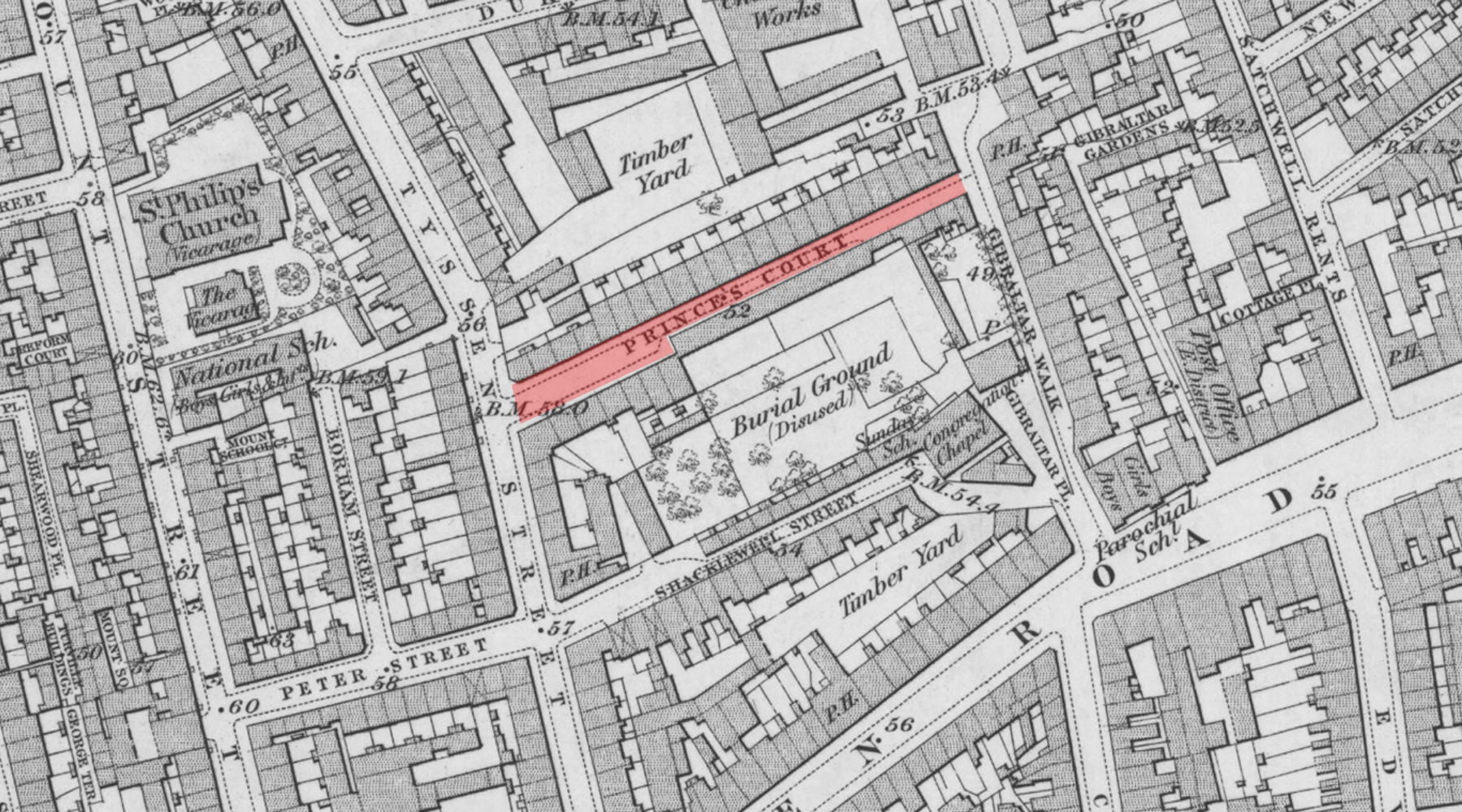
The development of the area takes an unexpected turn when a Congregational Chapel is built just to the south of the alley and also takes over much of the undeveloped land for a burial ground.
And the passage has been renamed Prince’s Court.
The chapel was built sometime in the 1760s-90s, in what was known as Gibraltar Fields, apparently a simple rectangular building for 200 people. It may have been rebuilt in the early 1800s as it shows up as capable of having 600 worshipers in 1838, but closed in 1877.
The chapel building is still there, on Shacklewell Street, although you’d never guess from its secular appearance of an old warehouse that’s now a photography studio.
OS map 1872
By the 1930s, the former graveyard had become a timber yard space and on 1st January 1938, the alley was renamed, again, this time to Padbury Court.
Today, the northern side of the passage is lined with post-war flats where a row of Georgian terraced homes had once lined the street. It wasn’t WWII that saw them demolished but post-war clearances. What was likely poor quality slum housing by the 1950s would, had they survived, be exceptionally expensive family homes today.
There’s an interesting example of literal ambulance chasing in the alley — because in 1955, a firm of fire assessors based in the alley were using radio equipment to eavesdrop on fire brigade messages to track where fires broke out so they could be first on the scene with their staff. They were caught and fined.

The order clearing the houses was given by the London County Council in April 1958, describing them as “unfit for human habitation”, and shortly afterwards, the current row of 1960s blocks of flats were built on the cleared land.
Although the row of houses on the north side were cleared away, the southern half survived and are now achingly fashionable warehouse conversions. The distinctive corner building was occupied by a bathroom suite seller in the 1950s, albeit one that looked close to closing down.

At the western end are three surviving houses of the sort that once faced them on the other side, and give you a slight hint, with the cobbled (setts) road and sash windows of what the rest of the passage would once have looked like.
Undeniably, the people who moved out of those unfit slum houses in the 1950s would have delighted to move into modern flats with indoor toilets and a modern kitchen, but it aches to think of the loss of the Georgian-era terrace.


I worked in one of the warehouse conversions in 1989. The shop on the corner, which looks like a bike shop in your picture had bars on the windows and sold knifes and guns. Across the road at the top of Brick Lane stall holders sold bric a brac with wares laid out in the pavement.
Fascinating that the chapel still remains. I’ve always wondered where this was — or is, as it turns out — because my 4x great grandmother buried her first husband at the “Gibraltar Burying Ground” in 1812 and I’ve long been charmed by that name. I’m much obliged to you Ian for filing in this detail for me.
I love your description of warehouse conversions as “achingly fashionable!”
Hope you don’t mind if I use it if the right occasion presents itself – with full credit to you, Ian!