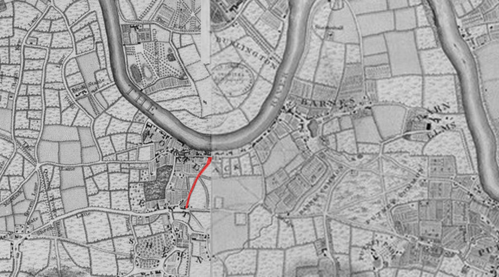
This is the remains of a once much longer path that later lost its southern half and would once have linked two main roads running through Mortlake in south London
The outline of the path dates to at least the 1740s, as it shows up as a path through fields in John Rocque’s map of wider London from 1746.
However, by the 19th century, as London expanded and fields turned into houses, the path became more clearly defined and straightened from its slightly curved layout when it was a path through fields.
The path started on the southern end at Upper Richmond Road next to a row of almshouses. It headed north to the railway, where a level crossing was replaced with a footbridge.
Today, that entire section is no longer a narrow path, but was rebuilt as a housing lined road and renamed Church Avenue in 1895.
What remains of Church Path is all north of the railway and continues the same slightly diagonal route, initially through a tree lined path. Then the trees vanish to leave a residential back-of-houses passage past the back of a local school, and then you see where it got its name from — the church.
This is also where the path ends, at the junction with Mortlake High Street.
The church, St. Mary the Virgin Mortlake, replaced a local chapel in the 1540s and its thought to be the first church built following King Henry VIII’s break from Rome as a fully Anglican church. It would have still looked Catholic, and richly decorated as it was later that Protestant styles would take over.
It’s speculative, but the manor around here was held by the Archbishop of Canterbury, but the reformist Archbishop, Thomas Cranmer exchanged the manor with the king for other lands — and the King later granted them to his queen-consort Catherine Parr, while also gifting a bit of the land to the church.
The 1543 building has undergone many alterations and enlargements during its long history and, of the original Tudor church, only the tower is intact now. The current appearance of the church is primarily the work of local architect Sir Arthur Blomfield, who built the chancel in 1885 and his firm built the nave in 1905.
The belfry and the cupola are distinctive features of the tower which appears as a landmark in many historic prints and pictures of the Thames bank.
The alley and church are linked though, as the alley used to be called Old Straight Track, and was used as a final passage for the dead from Sheen village in the south to the church for burial.
That stopped when the railway cut the path in half in 1846, and since then, it’s been much easier to arrive in a hearse.


Leave a Reply