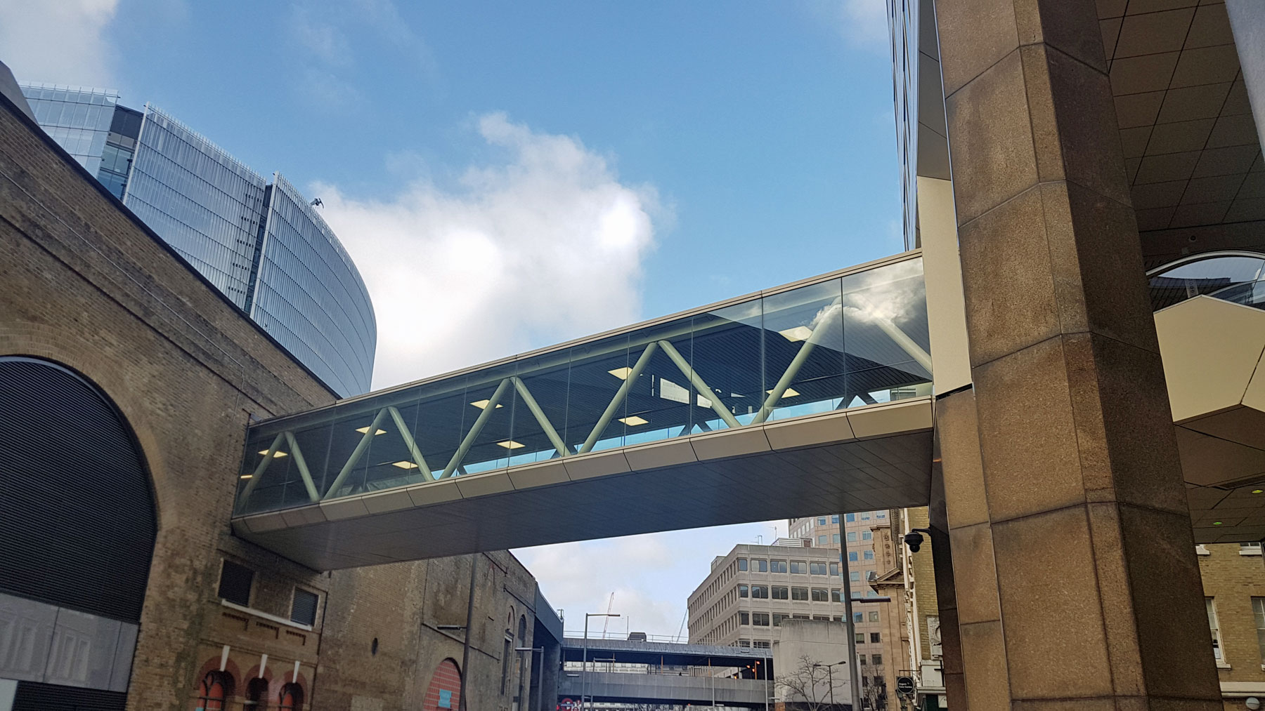
The covered footbridge that has linked London Bridge station with the 1980s development next to the river is to be demolished.

Built in 1986, it created a link between the mainline railway station and the shops/offices in what is officially, if rather rarely, called the Cotton Centre.
Although it was at the time a very useful route across the road from the mainline railway, since the station was rebuilt, most people now arrive at ground level and cross the street there. Although not entirely abandoned, the walkway is a bit of a ghostly echo now, and the cost of maintaining it will soon prove to be less than desirable.
The other issue is that at the Cotton Centre end, the escalators are on a raised dais which swallows up a lot of pavement space and is not disabled-friendly either.

Hence the plan to demolish it.
The hole in the wall where the footbridge connects to London Bridge station would be filled in with matching bricks, and ventilation slots, whereas the other side of the street will see the podium removed to open up more space on the pavement.

There’s a curious affection for the old footbridge. Its design fits fairly well with the 1980s buildings and with the floor to ceiling glass walls, it was never a pokey dirty old space to avoid. We can build up rather odd fond memories of paths like these, these familiar paths we tread that mark the start of our commutes home, or arrival at work.
Born of the aspirations of the docklands redevelopment, which included this part of town, its demise is due to another massive redevelopment – this time of the railway station.
Its no longer of much use to anyone, but I still suspect there may well be a few sad faces on the day a massive crane turns up to remove the walkway from its home.


The planning documents call it “Cottons” not “Cotton” centre and street.
Yes it’s always been CottonS Centre.
Sad news that, now we’ll have to take our chances getting across Tooley Street. 😔
So that’s both footbridges getting demolished in the near future (as the manky concrete block further along will get redeveloped at some point and there’s no need to retain the bridge) – this will push a lot of people onto Tooley Street, and the footpaths are already inadequately wide at peak times.
I always assumed this footbridge was part of the grand plan to move all pedestrian paths in central London up into the air – bits of which were implemented as building work took place at Charing X, Blackfriars, city etc etc. I think some of them (leading nowhere) in the city were only up a few years before coming down again?
Although it works well in many cities around the world, I think planners have gone off this idea of separating pedestrians from roads in such an abrupt way, preferring to have softer lines between transport modes (de-gyratory work an example of this).
I’m yet to understand how this approach sits alongside new technologies such as driverless cars that rather like dedicated spaces. I expect there are clever clogs out there solving these problems right now in Greenwich, MK etc. and I guess the answer will probably involve a clever mix of both approaches.
The recent (2017) serpentine “pedway” by the City of London Corporation along London Wall reaffirms their commitment to this form of high level pathway, and is aesthetically very impressive. No doubt Ian will visit it if he has not already done so.
No, it was just something built by the St Martins Property Group (who built London Bridge City in the 1980s) to connect Cottons centre to London Bridge station.
This bridge would make a lovely unusual Smart home or Restaurant 😂
I’d re-purpose it as a dual entrance café/ diner.
It would offer great views to its clients.
London constantly changes so much that I just cant recognise much of it, but I well remember regularly walking down Tooley Street in the early 1970″s before the bridge existed. Going down the steps from the station, past the opposing newspaper vendors of the Standard and Evening News on either side of the brick arch. So it’s just going back to what it was.