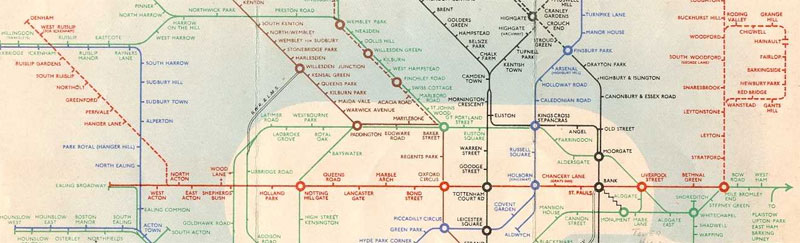
The latest edition of the tube map is missing something — an entire line has been omitted from the map — where is the Elizabeth line?
It may sound like an odd question, as of course, the Elizabeth line (née Crossrail) doesn’t start carrying passengers until December 2018, so of course, it’s not on the map yet.
Ahh, but, in the past, forthcoming lines were added to the tube map long before they opened to the paying public. Often many years before they opened.
Let’s take a trip down tube map memory lane.
1938
The Central line extensions were due to open in early 1940 (delayed by the war), but in 1938 they were already on the map, with construction well under way.
1968
The Victoria line, an entirely new line was partially open in September 1968 when this map was released, but showed the unfinished sections which were not due to open until the following year.

1977
It opened later in the year, but the Heathrow extension to the Piccadilly line was already on the map.

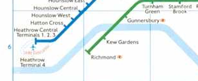
1985
Another Heathrow job, the loop for Terminal 4 wouldn’t be open for another year, but it’s on the map.
1990
Huge expansion of the DLR already shown on the map in 1990, but the extension didn’t fully until 1994.

1994
Construction started in 1993, but just a year later the Jubilee line extension would be a familiar sight to anyone looking at a tube map. It wouldn’t carry passengers for another 5 years.
Elizabeth line
So, where’s the Elizabeth line?
By historical precedence, it should be on the tube map today, as a dotted line marking the fact that it’s under construction.
This may seem like a petty issue, but putting extensions on maps before they open is important publicity. A lot of people still have no idea that there’s something called Crossrail going on, or that an entirely new railway will soon be running through central London.
Amazing, but true. And hardly a surprise that we all have different levels of awareness about something. Personally, I am about as aware of the latest celebrity gossip as some people are of the Crossrail project.
Aka, not at all aware of it.
Whatever the reasoning, we are now less than a year from the arrival of an entirely new railway line in London, and it’s about time a dotted purple line appeared on today’s tube map.

Older map excerpts via the London Tube Map Archive
Updated: 5th Jan 2018


I have a distinct feeling that it might appear soon
I may be insanely wrong, but I think that the ’38 car kept as a static exhibit in Covent Garden features Northern Line schematics including the Northern Heights.
Sadly not — but it does include what is today the Great Northern line into Moorgate.
I must have been thinking of this:
http://www.eplates.info/maps/LU1939-2_6_i.jpeg
I think in recent years there has been a trend NOT to include lines on the tube map until they are officially open. For example, I seem to recall the ELL southern extension appearing as a dotted line, then disappearing, then not re-appearing until fully open. Similarly, recent Overground take-overs haven’t appeared until after the fact.
Perhaps TfL discovered that they confuse some people, who might not read the key?
I know that the wider franchise has been having a hellish time lately, but the Thameslink (Snow Hill) core remains an off-map lovely secret, please tell no one! Saint Pancras to the Tate Modern in minutes.
You’ve just told us!
It’s actually another 29 months until the Elizabeth Line through London opens, not 18. The full line won’t start for another 41 months.
Whoops — I lost a year in my calculations!
Corrected.
With more and more non-solid lines on the tube map already, I’d say they don’t want to confuse people who do not read the key and might assume it’s “another one of those”.
Don’t forget that LT got their fingers burnt showing the never built Camberwell Green extension of the Bakerloo Line on a 1949 map.
A good piece again, Ian.. Sadly the Elizabeth Line is a fiscal disaster and transport minnow in all aspects – compared to the far better option of a multi-tier, multi-mode surface artery – connecting the Westway, Euston Rd, through to East London, etc. The latter would have cost one third of that of the Elizabeth Line, linked London’s northern termini for the first time, had 10 x capacity, far better reliability, could have been built in one quarter the time. Sadly Ken Livingstone – the mayor who emptied his own city – decided on the former. Moral of the story: No More Tunnelling!
Given the Tube Map comes under fire for being cluttered these days what with its increased complexity, it probably is better such luxuries are not taken.
Technically some of it is there, TFL Rail, the temporary service between Liverpool Street and Shenfield is now present on the map. Despite it being called TFL Rail, MTR manage most of the service and Network Rail obviously manage the tracks.
I think it may appear sometime later this year or early 2017. There is a lot of publicity around Abbey Wood station and quite a few other stations so I don’t think its really necessary to put it on the maps yet.
You answer your own question multiple times, the Elizabeth line is NOT an extention of an already working line, and ad yet ni part of it is open to the public, I imagine that we will see it on the maps closer to its opening.
Another ‘Update’ – a very timely and pertient one, IMO (so thank you) but perhaps that could be put at the top of the post, and not the bottom?
Why not?
a) It’s not technically a ‘tube’ line? Wrong size tunnels, goes too far out of London, etc?
b) It’s a scam and doesn’t actually exist! 😉
Seriously, perhaps we need – finally! – to get away from the concept of a ‘London Underground Tube Map’ map – which has ‘tubes’ which mostly run above ground, DLR, Overground (almost entirely overground) and trams on it, and have a ‘TfL Metro (or Rail)’ map for everything not buses ultimately ‘owned’ by TfL (regardless of who actually runs it, or who owns the ‘steel’ and the ‘wheels’ – or the stations)?
Is the Northern line extension to Battersea on there yet either?
Great Northern from Moorgate would be good too, regardless of who runs it…
Do users needs and expectations actually matter or are the organisations only looking at things from their own organisational perspectives?
Hmmmm…
This issue of what’s on the Tube Map has got rather political in recent years with TFL and The Mayor only wanting to show Services run by TFL . Which means unlike in the past when the Waterloo and City Line although part of British Rail and operated by South Western Region was shown on the tube map it seems Services like Thameslink in Zone 1 ( Kentish Town to Elephant and Castle/ London Bridge ) or Great Northern Finsbury Park to Moorgate are not shown on ordinary tube maps .
As for Crossrail/ Elizabeth Line we’ll firstly sections of it are operating lines and so you can’t show Shenfield to Liverpool Street or Paddington to Heathrow/ Reading as ” under construction!”. Of course Abbey Wood to Paddington via Central London could be shown as ” under construction ” with a dotted line from Whitechapel to Stratford and it would surely make sense to do this with the next ( May 2018) Tube Map when TFL will have taken over Heathrow Connect Services from May 2018 thus having a way of joining the dots !
Another issue which is raised in latest issue of Rail magazine is how despite publicity talking about interchange at Farringdon between Elizabeth Line / Thameslink TFL has no plans to add at least Zone 1 sections of Thameslink to tube map or indeed Finsbury Park to Moorgate branch .
Given how inaccessible the tube remains omitting these lines also makes life more difficult for disabled and elderly and wastes opportunities that arise after spending billions to make stations like Moorgate fully accessible. Just think someone arrives by Overground at Highbury and Islington who wants Moorgate looks at Tube Map will change to Victoria Line at H&I then Northern Line at KX and yet had they simply crossed to other platform at H&I they would have a direct 3 Stations journey to Moorgate !
Someone needs to bring back common sense re lines in Zone 1 whoever operates them !
Yes the whole ‘tube map’ concept needs a total rethink once Thameslink is up and running …I can see the ‘London connections’ map taking over – just ridiculous potentially having Reading appear on the tube map but not the Thameslink line between St Pancras and London Bridge
Addendum to my last comment – TFL say information is shown on the London and South East Map . However, TFL doesnt distribute this map at Overground stations let alone Tube stations so no joy there then !
The 1940 map seems to show the Central Line open from Liverpool Street to Mile End. Surely this part didn’t open till after the War?
Parts of the Elizabeth Line will open in December this year which includes Paddington-Heathrow Terminals 4 & 5 and Whitechapel-Abbey Wood. Then next year the Paddington-Reading section will start to see Elizabeth Line trains operating and the central section between Paddington and Whitechapel/Stratford will also see Elizabeth Line trains to start running with 24tph passing through Central London and Farringdon will become very busy. With trains running between Shenfield-Heathrow Airport, Shenfield-Reading, Abbey Wood-Heathrow Airport and Abbey Wood-Reading.
Perhaps these debates will become academic as digital maps such as CityMapper are increasingly adopted, even by tourists and non-Londoners. As such, there will be more choice of maps and, potentially, the option to personalise maps. CityMapper has been including the Elizabeth line for more than a year, even in journey planning, noting it is ‘fictional’. (Fascinating discussion, nevertheless.)
Not just before construction but after as well. I was riding a Bakerloo line train in 2008 once and noticed the map above my head showed the Jubilee line still terminating at Charing Cross!
I fear that regrettably the tube map is coming to the end of its useful life, however iconic it might be. It’s already very cluttered however hard the designers try, but what will make it obsolete is the availability of City Mapper, on near ubiquitous smartphones, which looks at all available forms of public transport and even tells you what each possible route costs. Its use is not limited to young people. At least this 75 year old uses it all the time.