I mentioned the other day that I recently acquired a copy of a City of London report into possible rebuilding plans for the City following the end of World War 2 and that it contains a lot of maps of the city, as it was in 1944.
They are quite large and stuck inside a hardback book so also therefore irritatingly difficult to scan in neatly.
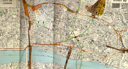
Nonetheless, I have made a go with the map which most interested me – Plan Number 1B – more usefully titled, Existing Railways and Subways.
- Brown = Overhead and Surface Railways
- Yellow = Open Cut Railways
- Orange = Cut and Cover (subsurface) Railways
- Green = Deep level (tube) Railways
- Red = Pedestrian Subways, toilets and tube/train station entrances and booking halls
- Dark Red = Service Pipe Subways
Interesting for me is that the Holborn service tunnels don’t seem to be marked to the West of Chancery Lane, although they are marked to the East of it. More research needed.
You may also notice the dotted green line – which is the second Post Office railway (the original pneumatic line not being marked on the map), although there seems to be an odd right angle length which I am not familiar with.
Notice also how the underground railways tend to follow the roads – that was to avoid paying wayleaving rights to the buildings above them.
In addition, there is the original City and South London Railway running to King William Street – later abandoned as the Northern Line was extended and improved.
Finally, if you know what you are looking at – notice how Tower Hill station seems to be in the wrong place. In fact that is the earlier Mark Lane tube station which was closed when Tower Hill was opened in 1967.
Other sizes – large and very large.


What’s the green line that stops under the east side of Liverpool St. Station?
The Central Line.
On the map, notice also that the connection between the Met/Circle line into platform 1 of Liverpool St is shown although it closed before 1920 (I think) . This is still noticeable at the northern end of the Met/Circle southbound platform as a curving wall. The ‘Sports and Social’ club occupied the connection inside Liverpool St station until the major rebuilding in the 1980’s
I love the way that this shows the ‘Mind the Gap’ section of the Central Line curving around the Bank of England.
Are those other green lines coming east out of Liverpool Street MailRail?
In the absence of confirmation information on the map, your guess is as good as mine.
Only the dotted ones are the PO railway.
Hello Ian, I was wondering if it was possible to post the map up to the West showing Holborn area and possibly down to Westminster if you have them? Many thanks.
This is a map from the City of London report – as such it wouldn’t include Westminster.
Ahh of course, my bad. Thanks for replying. Out of interest do you happen to know if the report book is held in the Metropolitan archives?
Probably – need to ask them.
I may be asking a stupid question but what are all the red lines? If the are pedestrian subways then I have never heard of them. For example there is a continuous red line running from temple gardens all the way to bank. *confused*
1) Ian, do you think the partially constructed GN&C extension to Lothbury is included with the marked tunnels at Moorgate?
2) Note that the Circle/Met/CWL are on their old alignment between Aldersgate St and Moorgate, and the Midland Rly goods yard is shown. The new alignment is over the goods yard.
3) It appears the Bank platforms of the W&C are rather longer than they are. I presume what’s show is the pedestrian subways linking on towards Bank. I’m colour blind so I may have missed a colour difference.
4) Notice that the Smithfield Curve is shown. This is before the fire of c1958 destroyed the Poultry Market. When that was rebuilt in the 60s, the new basement level was about half way up the former tunnel, rendering that route of no further railway use without deeper tunneling.
5) That dotted line running at right angles west from Moorgate St – I doubt whether it is part of the PO Railway – even that didn’t make right angle turns like that shown. Perhaps it is a pipe subway or a telecommunications subway?