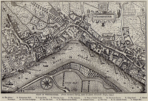
Another small map to add to my collection – this time a reprint of a map by John Norden for Queen Elizabeth.
Published originally in Speculum Britanniae in 1593 are considered to be the best representations known of the English metropolis under the Tudors. My copy was taken from “Old and New London” a series of illustrated topographical studies which were first published c.1883.
Interesting points to note:
The spelling of “Wes(t)minster” in the map itself.
The “way to St Giles” – although by then it had already adopted the suffix of “in the fields” by the time the map was made. Today, a church is still there, next to the CenterPoint tower.
Charing Cross on what is today the site of Trafalgar Square.
The area marked “Scotlande”, which was land ceded to Scotland for the use by the Ambassador and Royal Family prior to King James taking the English Throne. It later was the site of Scotland Yard.
The Great Hall at Whitehall, which is still standing as part of the Palace of Westminster.
Topical for today’s politicians might be Thieving Lane, so called, for that criminals were led that Way to the Gatehouse by Tuthil Street. Through the gatehouse, and in the very large version you can just make out the hangman’s gibbet in the new Palace yard, the criminal’s terminal destination.


Wow. That is very awesome :o)
(Though I can’t find Old Palace Yard and its gibbet, for some reason, despite knowing where it is :oS )
Gah, that was a 🙂 and a :S respectively 😛
It’s just above the letter B in The Palace.
I suspect it would be close to the corner of Parliament Sq today – someone should set up a replica.