Not far from the south side of Heathrow, at Feltham, a new railway depot is being built, to increase capacity on the Waterloo to Reading and Windsor lines.
In addition to increasing capacity on the lines, SWR has the ambition to be able to run a more frequent “metro-style” service on the line between Windsor and Waterloo.
To do that though, they need more storage for a fleet of new trains, and thanks to a historical quirk, such a plot of land exists next to Feltham railway station. The sidings are being built on the disused Feltham Freight Marshalling Yard which were themselves a huge railway marshalling yard, that was built in 1916/18, aided by around 200 German prisoners of war.
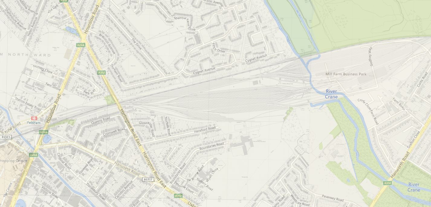
Marshaling yard overlaid on modern map
However, with declining railway traffic at the time, the marshaling yard closed in January 1969. Fortunately, while some of the site was sold off, the rest of the land was never developed, and has always been technically classed as “railway operational”, even after it had long been returned to grassland.
Works have been underway for some months now, and the bank holiday weekend saw the initial phase of vital new cabling and track connections take place. Work is set to continue over the next few months to connect the eastern and western parts of Feltham to the mainline infrastructure in time for the arrival of the new trains.
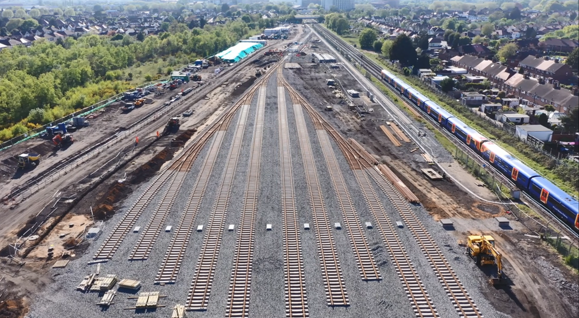
Feltham depot under construction (c) Network Rail
The design of the new stabling facility is expected to include the provision of 10 of the new 10-car Class 701 trains that the company is ordering, although it could be used for other shorter trains as needed.
There’s a video flyover of the new depot here.
Feltham Depot – May 2020 from South Western Railway on Vimeo.


Does anyone know why there is a culveted drain/stream across the site?
On GOOGLE Earth, it looks like it could be an old canal. If you trace the route to the North East across the M4, it appears to meet the Grand Union Canal just east of the Norwood Green Lock.
Big water main coming from Kempton water works serving much of north London .
Interesting that prior approval for the Railway work was governed by the “Railway Clauses Consolidation Act 1845 ” !!
“Section 16 of the Railway Clauses Consolidation Act 1845
Subject to the provisions and restrictions in this and the special act, and any act incorporated herewith, it shall be lawful for the company, for the purpose of constructing the railway, or the accommodation works connected therewith, here in after mentioned, to execute any of the following works; (that is to say) They may make or construct, in, upon, across, under or over any lands, or any streets, hills, valleys, roads, railroads, or tram roads, rivers, canals, brooks, streams or other waters, within the lands described in the said plans, or mentioned in the said books of reference or any correction thereof, such temporary or permanent inclined planes, tunnels, embankments, aqueducts, bridges, roads, ways, passages, conduits, drains, piers, arches, cuttings and fences as they think proper;……”
Hounslow Planning Reference 00553/F/PA3
There were many mills along this waterway which is a glorified mill race.
https://en.wikipedia.org/wiki/Duke_of_Northumberland%27s_River
https://maps.nls.uk/geo/explore/#zoom=15&lat=51.45325&lon=-0.39302&layers=6&b=1
Let’s hope there’s Room for some London Overground Trains for the new Hounslow to Brent Cross West Line ( and possibly further) it would be a shame to revisit this the Day after the Depot becomes Operational.
A Contract Variation or a Complete new Works Order?
This new momentum should involve Maynard – Keynes Stimulus and or Private Sector Involvement at Historically Low Interest Rates, the next 3 years may be bleak for England and Wales, who knows?
@Kit Green – It’s the River Crane by that point, and the Crane runs through the trees (actually in a culvert under the trees) at the east end of the new sidings. The Duke enters the Crane at Baber Bridge (North Feltham Trading Estate).
@Tim Henderson – It’s interesting that you can more or less follow the route of the main all the way to the GUC in Norwood Green. It would be interesting to see a map of the main water mains in London, but google drew a blank (without paying a water authority).
I wonder if there is a map at Kemption Steam Museum – Currently closed, so I can’t go and look.
According to
https://www.geograph.org.uk/photo/3689155
there is a 42″ and a 48″ main going all the way from the treatment works at Kempton Park to a pumping station at Cricklewood !
Many happy memories from regular visits as schoolboy 1953 – 1959.
Friends and I so well known by staff we had unofficial rides on diesel hump shunters and I even had a footplate ride to Nine Elms and back! Glad to see it’s got a new lease of life.
At least the River Crane is easier to deal with than the Duke of Northumberland’s River (which is marked as the Queen’s or Cardinal’s River on the Scottish map).
The Duke of Northumberland’s River, which runs under Feltham station, was originally built to supply water to Hampton Court. It is hence a Royal Park and has the same protection as Hyde Park or Regent’s Park. As such, it can’t be undermined – which is why the Piccadilly line has to emerge from tunnel, solely for the purpose of crossing it!
Sorry – but totally wrong.
The river was nothing to do with Hampton Court, is not a royal estate, has been moved around several times during Heathrow’s expansion, and the reason the Piccadilly line goes over it is because at that point the line is in a cut-n-cover tunnel and its vastly cheaper to go over a river than under it at that shallow depth.
The river that runs under Feltham station is the Longford River, The Duke of Northumberlands River runs on a west east direction north of the A315 Staines Road and discharges in to the Thames at Old Isleworth, it does not go near Hampton Court.
River crane runs across the site east end.
There was public right of way along the river bank, through a passage beneath railway tracks, locally called ‘cavalry tunnel’. Presumably the name was from the 19th century army barracks on Hounslow Heath, now surrounded by housing.
By 2000 the passage was fenced off due to a standoff about financial liability for public safety between railway authorities and Hounslow council.
Was the passage included with riverbank rebuild for the new depot sidings,
for walking between Hounslow Heath and Crane River Walkway, or did council abandon its aim of public access along all the Crane River ?
so will there still be some kind of public thorofare ,track,fenced diverted, tunnelled path acessing crane park
and donkey wood when when the bulldozers have been removed?
To clarify,from LSWR Engineering Committee Mins at National Archives(ref RAIL 411.64)for 22/5/1915. It refers to a proposal to purchase more land than initially acquired for the new ‘gravitational yard’.
“Read Mins of Traffic Committee of this date, recommending the purchase of further land at Feltham, containing 18a 2r 23p in connection with this scheme… 17 acres belonging to Sir Frederick Pollock..(&)..1a 2r 23p, occupied by the bed of the Crane & its Western Branch…will have to be acquired from the Duke of Northumberland.” Committee agreed.
Ah, this is the third lot of track to be laid here.
The LSWR acquired some second hand 2 ft gauge track, plus tipper wagons, to help in construction.
Anyone know what happened to that when it was no longer needed?
Hi ,am I correct in thinking this is where the majority of the new Seimans rolling stock will ultimately be cleaned and maintained ?
Also is this maintenance light daily work and / or heavy detailed overhaul ?
I believe Siemens already have their name on one of the buildings and it looks like a train wash is being built – I wonder if Seimens are paying for the whole project?
The 48 inch water main from Kempton Park Does not stop at Cricklewood, but continues on under Temple Road and The Vale. It’s path can be seen as gaps between buildings all the way to Fortis Green pumping station in Woodside Avenue N10 where I think it finishes.