Continuing the walk around modern London following the route of the lost fortifications erected during the English Civil War.
Notes:
- Bulwarks and redoubts were types of fortifications – basically small forts.
- Hornwork was another type of fortification, usually built near a larger fort or building to create another layer of defence.
- Flanks were the sides.
- A battery was a strong position that held one or more cannons.
- Breastwork meant steep mounds of earth or stone with fences to stop attacking forces.

Or download all 5 articles onto a Kindle device
Day 2 – Waterfield to Bedford House
9) A Large Fort with four Half Bulwarks, at the New-River Upper Pond.
A little further (about ten paire huts) I approached to Islington hill, where there is erected a most rare and admirable fortification, called Strawes Fort, but now Fort Royall. It hath eight angles, and a specious interlarding distance between each of the cornerd bulwarks. This fort is marvellous perspicuous and prospective, both for city and countrey, commanding all the other inferiour fortifications near and about that part of the enclining grounds. The north-east corner bulwark is double altified above the rest of the worke, carrying, on the two sides thereof, six cannon royall; and the two south and west corners are mutually charged, on each of them, with two half culverins of brasse; and the east promontoriat corner adorned with three whole cannon. The altified bulwark is twice pallosaded; and, at the root of the work, answerable to the top of the inmost ditch, it is strongly barrocaded: the middle place, between the two ditches, is en- ravelled all about with low wooden stakes, and long pikes of throwne pointed iron : and without all which works there is a breastwork cast up, and made defensive, either for the first assault or for the second invasion.
 Head westward along Myddelton Street, which again, probably follows the line of the wall, noting the rather charming row of shops, and take a look at the pavement for a wide variety of coal hole covers along here.
Time for a detour, and at the main junction, turn right up Amwell Street, and if the reports are correct, you are now walking along a line which marked a covered walkway leading to a huge fortification.
Whether it was simply covered for convenience, or to camouflage it is unknown, but heading along Amwell Street, you’ll come to Clarmont Square.
This alluringly tempting huge mound is the site of the might fort to protect London’s water supply, but what you are looking at is actually a 19th century covered reservoir.
Hints of the covered walkway as a path through the fields can be seen in Bowles’s Reduced New Pocket Plan of 1775.
10) A Battery & Breastwork, on the Hill East of Blackmary’s hole.
Descending thence to Holbume fields, I accoasted a strength, named Pinder of Wakfields Fort, being onely quadrangled, pallosaded, and single ditched, and enstalled with five great ordonance, and a court du guard.
Heading back to the main wall around the city… back track down Amwell St., and turn left then when you get to the junction with Exmouth Market, then turn right into the famous street market.
This street also marks an old barrier, the south being built up in the second half of the eighteenth century, facing open fields until the northern side was built following the end of the Napoleonic Wars in 1815.
 Also along here is the Church of the Holy Redeemer, which was built on the site of an older church in 19th century. On the inside, it’s a fairly routine church, so unusually, the exterior, which is certainly distinctive is the best feature.
Carry on the end, and crossover so you are standing opposite the Post Office, near some old subterranean toilets. The toilets aren’t that interesting, but the location is — for this is where a limited trial of a Pluto Lamp took place.
The odd street lamps included a vending machine facility that would sell hot water, beef broth, and even cigarettes. More about them here.
 Head past the fire station to the road junction, and roughly around here was the next Fort. This is also described as being at Black Mary’s Well, which also has the salubrious distinction of being the first recorded gay cruising ground, in 1705.
The site was also a small pox hospital, and at one time, a rubbish mound where the spoil of human waste was piled up. Today it’s the post office sorting centre, and (from August) a museum for the underground Mail Rail.
11) Two Batteries & a Breastwork, at Southhampton, now Bedford-House.
Abandoning the place, and shoaring along the trench a little further, to Longfield, I presently rancountred with Northampton Fort, consisting of two divided quadrangled bulwarks, and each of them garnished with foure demi-culverins of brasse; the interveening distance fortified: the two former bodies are pallosaded, double ditched, and the middle division whereof barrocaded with stakes a yard high, and each of them hooked with three counter-thwarting pikes of iron:
At last, a fort where there is no ambiguity about its location!
Carry on along Rosebery Avenue. This is a fairly new road, that was opened in 1892 to replace a warren of smaller streets and smooth the path in this very hilly part of London. As you walk along you’ll notice a couple of viaducts as the now level road passes over valleys it used to run up and down.
 Carry on to the junction with Theobalds Road, passing one of the few remaining buildings from the slum clearance, the Christopher Hatton Primary School.
Carry on along Theobalds Road, and on the left, the high wall and garden is the back of Gray’s Inn, one of the ancient legal training houses. As you pass Holborn Library, maybe a quick visit inside, as they often have local history exhibition upstairs.
Carry on along until you reach the junction with Southampton Row.
 Just to your right on the opposite side is the impressive Victoria House, formerly home to the Liverpool Victoria Friendly Society. It was built in stages, as former houses didn’t vacate the block it sits on for upwards of a decade after construction started.
To your left is the slope in the middle of the road that leads down to a tunnel running down to the Thames for tram services. Now it’s empty, although used for storage, and at the time of writing, by Crossrail for works.
Cross over and walk up past Victoria House to the first turning, into Bloomsbury Place and head along until you are at the park, Bloomsbury Square.
To the north, along Bedford Place is provably the location of the fort. The site of the fort later became Bedford House, and you can clearly see the outline of the remains of the fort in John Rocque’s Map of London of 1746.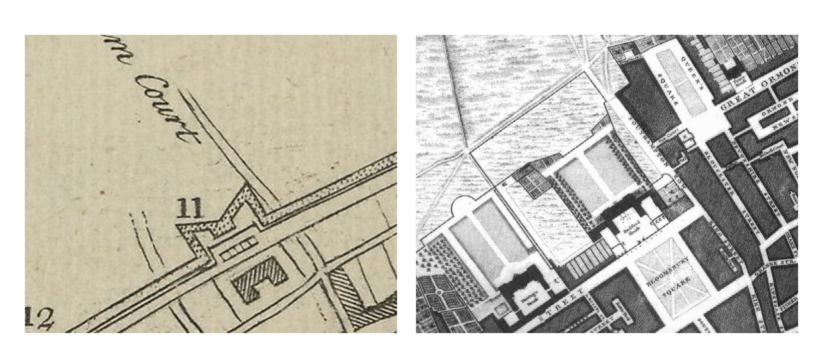
If you fancy getting an idea of the size of the fort, walk up Bedford Place to Russell Square Gardens, which sits at the other side of the fort, to get a feel for how large a plot of land it took up.
12) A Redoubt with 2 Flanks, near St. Giles’s Pound.
13) A Small Fort, at the East-end of Tilburn Road.
Whence, conducted along with the trenches through S. Geilles fields, I arrived at Crabtree Fort, in Crabtree fields, standing in a quadrangle, and loaded with six culverines of brasse, placed on the two field corners, defying the malignants, or what assailants may there encroach: the fort is pallosaded above, double ditched below, and barrocaded, in the middle division, with thick standing stakes, and they conterbanded with thwarting iron pyks ; and a stately court du guard within.
Carry on along Bloomsbury Place past the British Museum towards Tottenham Court Road, but stop at Museum Street and turn down here for a short diversion. Head to 32 Museum Street, which is (at time of writing, a fish and chipie). In 1995, a rear basement was excavated here, and archeology carried out.
What was uncovered by Robert Cowie of MOLAS was “a sequence of 17th-century deposits appeared to fill a large feature – probably a quarry pit – which cut the natural gravels and may have been associated with the Civil War defences just to the north of the site.”
Back up to the museum and turn left to head again towards Tottenham Court Road, passing the brutalist YMCA building on the corner, and turn left and head to the junction.
The land to the south of the junction is thought to be the site of the fort, although it’s exact location is still unsure. Some thoughts could put it a bit to the north where some maps have shown earthworks, but that doesn’t really fit with the other sources. Anyway, it’s likely that underneath the theatre you’re standing by lies the earthwork remains of the old fort.
And also, probably on the other side of the road stood its smaller partner.
14) A Large Fort with four Half Bulwarks, across the Road at Wardour Street.
15) A Small Bulwark, at the Place now call’d Oliver’s Mount.
Leaving this, and marching along the circulary line, it grieved me to see so many rich grounds ofgrasse utterly spoyled with the erection of these works, insomuch, that horse and cattell certaynels will come short of their food there for seven years, and the owners thereof must fall pittyfully short of their yearly profits; for where trouble is, then cometh misery. Having left the aforesaid fort, I saluted the Banqueting house fortresse, composed of two forts upon Tayburne way and Maribone fields : here I found both the forts answerable to other, the way only divyding them ; and they both pallosaded, double ditched, and barrocaded with iron pyks; the onecled with eight demi-canon, and the other fenced with foure semi-culverines of iron; both wondrous defensible.
A little advanced from this Tayburnian passage, I insulted upon Serjeants Fort, composed mainly of foure angles, a court du guard, five piece of ordonance, and fortifyed, in all things, just like to the former.
This fort is incredibly difficult to locate. The map says that it was to the north of Wardour Street, and indeed, some later maps show a lot of earth disturbance in that area.
However, the writer says that he saluted the Lord Mayor’s Banqueting House at Tyburn — and that places it just to the north of modern day Bond Street. This has caused confusion with writers putting the fort in two different locations.
Incidentally, the site of the Lord Mayor’s former Banqueting House is still easily identifiable, as the site is now occupied by Derby House, at the top end of Stratford Place.
But back to the 17th Century, where was the fort? I think there could be a misreading of the writer’s own words, in that he may have meant that this region of London was known for the Lord Mayor’s house, so the map could be correct.
There was a fort “upon the Taybounre way”, and a second in the “Maribone fields”.
That accords with the map.
 So, head along the former Tyburn Way – now Oxford Street a bit and just opposite Wardour Street, where today its all shops was once a large fort, possibly straddling Oxford Street as well.
The possible site is today occupied by the Plaza shopping centre, which is currently being converted into a giant branch of the clothing chain, Next. The site used to be the department store, Bourne and Hollingsworth, which opened in 1902, but in its final years became famous for it’s seemingly never ending Closing Down sale.
To get to the next fort, which is in now very posh Mayfair, we could try to follow the rough line of the fortified wall, but so much has been lost now that it would be almost impossible to trace the route without getting hopelessly lost.
So lets avoid crowded Oxford Street and head down Wardour Street then take the first right into Noel Street, Stick to the north side, and keep an eye on the south side walls, for a hundred yards will reveal a giant mural, known as the Ode to the West Wind.
 Painted in 1989, its name is a reference to the poem written by Shelley when he lived in Soho.
Carry on along Noel Street as it transforms into Great Marlborough Street. You are on land that was once taken by King Henry VIII, but was developed into a street in the early 18th century.
Although few original buildings survive, the street is famous for one Tudor inspired occupant, at the far end is Liberty, with its mock Tudor department store.
The mock tudor building was actually built in 1924, and the timbers that were used to decorate it came from two old Royal Navy ships that were being decommissioned.
You’ve reached famous Oxford Street, so cross over and carry on straight ahead down Maddox Street.
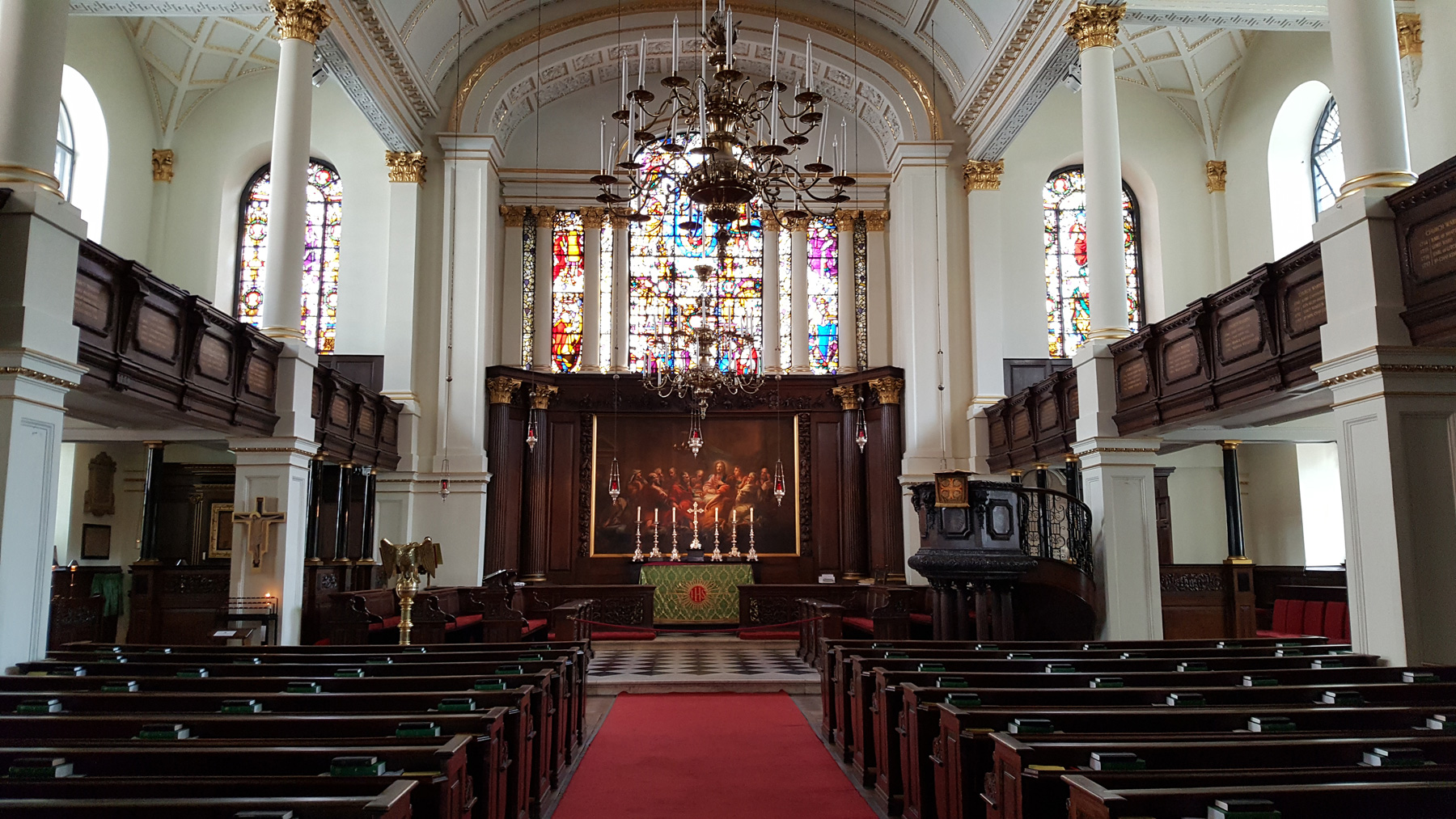 Towards the end as it curves, you’re walking around the back of St George’s Hanover Square, one of Queen Anne’s 50 churches of 1711, and funded by a tax on coal. Go around the front, and usually the doors are unlocked to wander inside to admire the 16th century glass, and the huge organ above the entrance.
Head out of the church, and turn left to carry on down St George Street. Just before the end, in the row of small shops is one of London’s best antique map retailers, Altea Gallery, and even though few of us can afford the maps, the window displays are always worth a diversion when in the area.
Carry on down to Conduit Street and turn right.
Unsurprisingly from its name, it was laid out by the City of London in the 15th century to secure the supply of fresh water from a conduit in the area.
 On to Bond Street, and at the junction notice the Time Life building, and just to one side on the wall, the artwork. These are by Henry Moore.
The building is also notable , being built as the London headquarters for Time Life, it was an expression of confidence in post-war Britain, and was the first major commercial building in London that was not subject to post-war building restrictions.
Cross over to Bruton Street, and I need not point out the pub you’re about to walk past. Although there’s been a pub on the site since the 1770s, the one you are looking at is a mock tudor rebuild following serious damage to its neighbour in 1933.
Carry on along to grand Berkeley Square, and head around the north side to the far corner, to the long posh street lined with grand buildings.
This is Mount Street, and somewhere here was the other civil war fortification. Mount Street’s name comes from Mount Field, which included Oliver’s Mount, the fort we are looking for.
The exact location is unknown, it’s just somewhere hereabouts, so lets head on to the next site.
Part 3 tomorrow, or download all 5 articles onto a Kindle device.


