The world as a jester, the unseen effects of comets, non-existent islands, the secrets of the stars, make up a richly decorated compendium of maps from the National Maritime Museum.

It’s a book that opens with a globe, of the earth, but one that was repainted in 1909 to show the landscape of Mars, with its seas and canals, as they were thought at the time. But it went beyond the simple recording of what could be seen, as the artist, Ingeborg Brun also gave places names invoking a mix of her Christian and Socialist beliefs about how a utopian world would look.
It’s a reminder of how maps are rarely simply catalogues of what is there, but often tools of political power, laying out boundaries between us and them and defining our identities as belonging to certain cultures and histories. Yet they can also be beautiful, which can be a challenge with maps that are clearly being used to justify the oppression of people by rewriting their borders without their say about it.
The book spans about eight centuries, from a 1282 manuscript map of Mesopotamia by Abu Ishaq Ibrahim ibn Muhammad al-Farisi al-Istakhri, to the latest, a football globe made for Mark Wallinger’s First World War centenary artwork.
It’s not a chronology of maps, but more a thematic review of maps and how they’ve been used and created over the centuries. From the materials they’re made from, to the sea dragons that appear on them, through engraving, navigation, and borders, and away from maps – the globes.
The book is beautifully illustrated, with whole pages given over to reproductions of the maps, probably about two-thirds of the content is images of the maps being described.
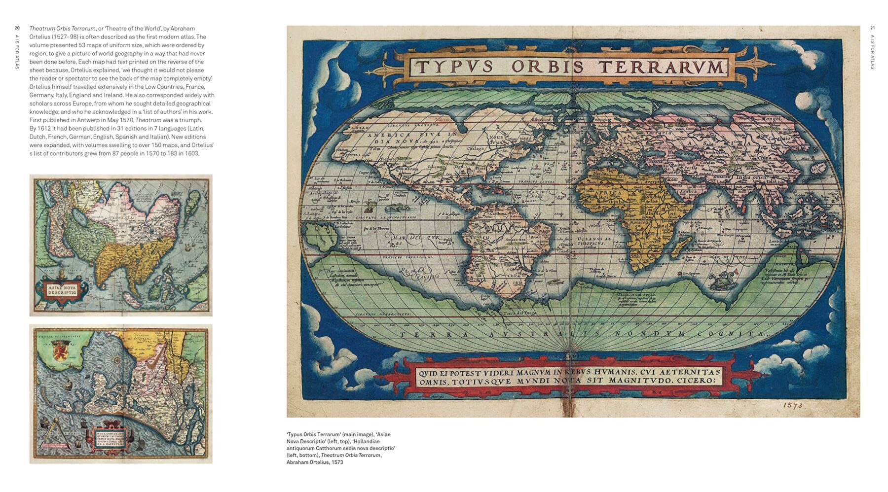
Extract from A is for Atlas: Wonders of Maps and Mapping by Dr Megan Barford
One of the earliest maps to be engraved in England is included, and it shows the path of the Spanish Armada around the UK, illustrated with the Protestant winds that scattered the Catholic fleet. Like so many maps, made for propaganda reasons.
Another section looks at decorative maps, and Londoners will be fascinated by the large scale poster maps produced by the Port of London to show off the size of its operations along the Thames to prospective cargo ships. Later in the book, abandoned schemes such as Reveley’s plan to straighten the Thames into a canal gets a look in amongst maps that were used for planning future ideas than recording current ones.
Maps can also reveal the hidden world, and while we may think of mapping the ocean floors, one fascinating map from 1869 shows the effects of Halley’s Comet on earth’s magnetic field. Something that’s not just invisible, but that I had no idea even happened.
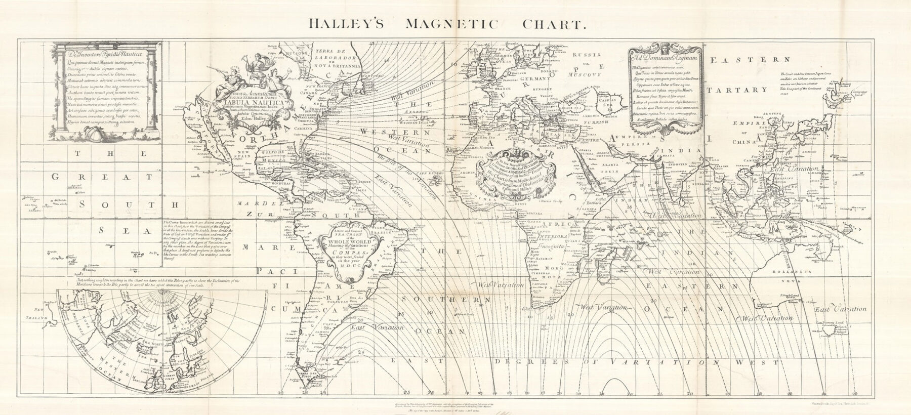
Halley’s Global Magnetic Chart, 1744
Then again, the less said about the anthropomorphic map of England shown as a man shitting over France, maybe the better.
Maps were pretty good considering the technologies of the time, although map makers did sometimes tend to guess what might be there if they didn’t have evidence. This is why a two-page map of the Americas shows a huge island just off the eastern seaboard of the USA – The Baja California peninsula, the map being made long after it was known that the island was a peninsula. Other mapmakers are more honest, leaving holes where there’s a lack of information, and the book ends with the unknown. From maps of terra to the map globes of the moon showing half the moon as a blank space as no one knew what lay on the other side.

Map of North America by Herman Moll, circa 1712
Something not mentioned, but obvious when you spot it is how the centre of maps move around over the centuries. Early medieval maps made in Europe usually centred the world on Jerusalem, and only later on central Europe. Many maps today centre on the Atlantic or Americas.
Part of the rationale for producing the book has been that many of the maps in the book are too fragile to put on public display, so this is a good way of showing them off to the wider public.
It’s more than just a picture book though, it’s informative, at times funny, but always beautiful to look at.
With over 150 images in it, A is for Atlas: Wonders of Maps and Mapping is by Dr Megan Barford is Curator of Cartography at Royal Museums Greenwich.
It’s available from Amazon, Foyles, Waterstones, the National Maritime Museum and local bookshops.


Baja is off the western seaboard?
Is there a reason why you’re asking?
Your text – ‘…two-page map of the Americas shows a huge island just off the *eastern* seaboard of the USA – The Baja California peninsula…’