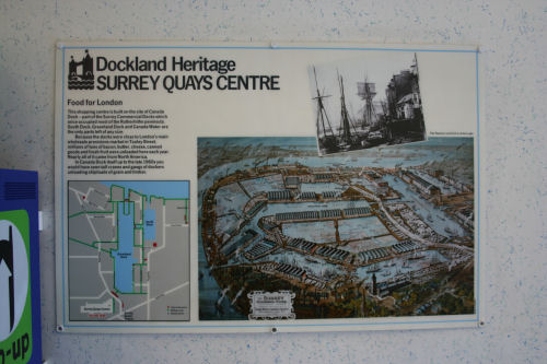
I was in the Surrey Quays shopping centre yesterday while visiting an estate agent, and just outside the toilets is a sign which shows some of the history of the area.
It sometimes surprises people that the “docklands area” isn’t just the bit on the north side of the river and mainly in the Isle of Dogs, but was actually a vast area running on both sides of the river from Tower Bridge down towards the modern Thames Barrier. Prior to the 1980s, the trend had been generally to fill in the docks and build over them, so a lot has been lost under housing and offices. It was fortunate that the Isle of Dogs did not suffer the same fate.
It was quite a nice image, so I took the below image, and you can click to see a much larger version on my flickr account.
SUPPORT THIS WEBSITE
This website has been running now for over a decade, and while advertising revenue contributes to funding the website, it doesn't cover the costs. That is why I have set up a facility with DonorBox where you can contribute to the costs of the website and time invested in writing and research for the news articles.
It's very similar to the way The Guardian and many smaller websites are now seeking to generate an income in the face of rising costs and declining advertising.
Whether it's a one-off donation or a regular giver, every additional support goes a long way to covering the running costs of this website, and keeping you regularly topped up doses of Londony news and facts.
If you like what you read on here, then please support the website here.
Thank you


