This is rather spiffy. Google has “officially” added some antique map layers to Google Earth so you can compare todays sat photos with maps of places from a hundred or so years ago.
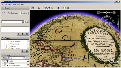
To use this, expand the Featured Content -> Rumsey Historical Maps in the Layers panel.
While this is an official Google service, they are not the first people to do it.
The rather good blog, Digitally Distributed Environments did a similar thing some time ago (and they used an older map!).
SUPPORT THIS WEBSITE
This website has been running now for over a decade, and while advertising revenue contributes to funding the website, it doesn't cover the costs. That is why I have set up a facility with DonorBox where you can contribute to the costs of the website and time invested in writing and research for the news articles.
It's very similar to the way The Guardian and many smaller websites are now seeking to generate an income in the face of rising costs and declining advertising.
Whether it's a one-off donation or a regular giver, every additional support goes a long way to covering the running costs of this website, and keeping you regularly topped up doses of Londony news and facts.
If you like what you read on here, then please support the website here.
Thank you


